De Biesbosch, un parc naturel façonné par la main de l'homme
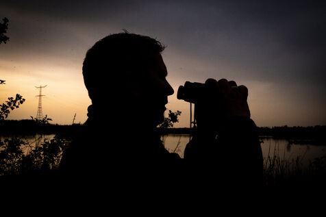
Harm est l'un des gardes forestiers du Parc National De Biesbosch situé aux Pays-Bas et plus précisément au sud de Rotterdam. Plusieurs fois par semaine, il arpente sur son bateau ces forêts marécageuses pour observer le site et comptabiliser la biodiversité unique qui s'y trouve faites notamment de fleurs, d'oiseaux et de son animal le plus emblématique le castor.
L'originalité de ce parc national est d'être particulièrement récent et d'avoir été en grande partie façonné par la main de l'homme. Alors qu'il s'agissait auparavant d'un territoire peuplé d'agriculteurs exploitant les terres, c'est au 14ème siècle que l'une des plus importantes inondations de l'histoire des Pays-Bas submergea totalement la zone. Petit à petit, des ilots se formèrent par les courants mais ce phénomène fut décuplé par le développement de la culture du roseau. Les plantations agissant comme des pièges pour les sédiments, cela entraina la formation de cet archipel. Au fil des siècles, les néerlandais continuèrent de développer la poldérisation de leur pays et sa protection des inondations. Ainsi, cela pérénisa la zone même si elle reste particulièrement vulnérable à la montée du niveau de la mer.
Cette particularité n'enlève rien à la richesse de cet espace naturel. En effet, ces forêts marécageuses en font une zone humide servant le maintien de la biodiversité bien au-delà des frontières des Pays-Bas.
Textes et interviews sur demande.
De Biesbosch, a nature park shaped by the hand of man
Harm is one of the rangers at De Biesbosch National Park in the Netherlands, south of Rotterdam. Several times a week, he takes his boat out to observe the marshy forests and to count the unique biodiversity that can be found there, including flowers, birds and its most emblematic animal, the beaver.
The originality of this national park is that it is particularly recent and has been largely shaped by the hand of man. The area was once populated by farmers who farmed the land, but in the 14th century one of the largest floods in the history of the Netherlands completely submerged the area. Little by little, islands were formed by the currents, but this phenomenon was increased tenfold by the development of reed farming. The plantations acted as traps for the sediments, which led to the formation of this archipelago. Over the centuries, the Dutch continued to develop the reclamation of their country and its protection from flooding. This made the area more permanent, even though it is still particularly vulnerable to rising sea levels.
This particularity does not detract from the richness of this natural area. Indeed, these swamp forests make it a wetland that serves to maintain biodiversity well beyond the borders of the Netherlands.
Texts and interviews on request.